Johnson Mesa:
Yes, it probably really is not a secret, but we seldom see other people up there, and that's how we like it.
quote:
From Wikipedia, the free encyclopedia
Johnson Mesa is an 8609 foot (2624 meters) mesa in Colfax County in northeastern New Mexico just south of the Colorado border. The city of Raton is on the west and Folsom on the east.
The mesa is named after Lige Johnson who lived below the mesa but grazed his cattle on top of it. Grazing on top of mesas was a traditional practice throughout northern New Mexico, where some mesas to this day are known as potreros.
Structures on the mesa include the abandoned farming town of Bell (1880s-1933) and St. John's Methodist Episcopal Church, dating from 1898.
Natural features of the mesa include a few lakes, the two largest of which are Berry Lake and Bellisle Lake, and a large hill called Red Mountain. The Dry Cimarron River, which becomes the Cimarron River, has its beginning on the eastern side of the mesa.
The mesa is crossed east-west by New Mexico State Road 72, part of the Dry Cimarron State Scenic & Historic Byway
If you are in a hurry from Clayton to Raton, New Mexico, you take highway 64. Just pay a lot of attention to the ridiculously low speed limits as you drive through Clayton. The limits are for revenue generation, not safety.
But if you like narrow, twisty, two-lane roads, and amazing scenery, take an hour or so to take the 45 mile diversion across Johnson Mesa.
If you've done the Raton-Clayton trip on highway 64, you'll notice the mesa just north of the highway. That is Johnson Mesa.
Stop for a bathroom break at the rest area about 5 miles south of Des Moines, NM. Impress your kids with your gelogy knowledge as you point out a shield volcano (Sierra Grande) just west of the rest stop. Then, as you pass through Des Moines, look for highway 72/325 to Folsom. Turn right and follow the road to Folsom. Pass the cinder cone where they are mining bright red volcanic cinders and the winding railroad track where Black Jack Ketchum robbed trains.
Go through Folsom, an almost-ghost town that survived the 1908 flood that came off of Johnson Mesa. Turn right at the museum, then look for a very quick left in about 100 yards to take 72 across Johnson Mesa.
We've never stopped at the museum, but we'd like to. If you are stopping at Capulin, go north from the Capulin volcano on 325 to Folsom.
Some other time when you have time, take 456 north out of Folsom a few miles and visit Folsom Falls, and go a little further north to see the beautiful valley of the Dry Cimmaron. You can even take 551 through Tollgate Canyon, where a local built a road, blocked off the pass and collected money from cattle herds being driven through. 551 leads on through to Branson, Colorado, and you can take US 160 on to Trinidad, Colorado, a good, but desolate road.
I'm not sure exactly where, but parts of the Dry Cimmaron were part of the "Cimmaron Cutoff" of the Santa Fe Trail.
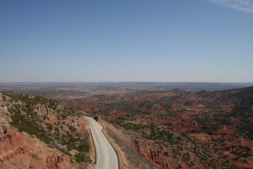
But back to highway 72 across Johnson Mesa. As I said before, it is narrow, has sharp drop-offs and winds around. You have to be alert and the driver may have to stop to enjoy the scenery and avoid driving off the road.
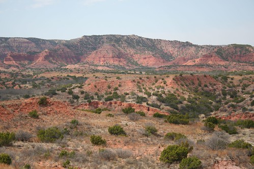
The mesa has overlooks south into New Mexico, and north into Colorado. If you know what you're looking for, evidence of lava flows is visible, and to the south you can see Capulin and many other cinder cones.
Somewhere to your left as you climb to the top of the mesa is the site where the Folsom point was discovered by a black cowboy who was the self-educated son of slaves.
To your right will be a dirt road through Trincheras Pass to Trincheras, Colorado. This is the path Charles Goodnight took when taking his cattle to his grazing lands near Trinidad. Old Charlie was NOT going to pay a toll.
As you break out on top, the trees suddenly disappear and you are in the middle of a vast grassland. There are a lot of rock cairns used as corner posts for the barbed wire fences. The bluebirds love these, so watch for them.
In the middle of the mesa is an interesting 1898 Church. It has been open when we've been through, and there are some porta-potties in the parking lot if the kids are desperate.
You let down on the other side of the mesa through more wooded country, and you have a stop sign where 72 meets the road to Sugarite Canyon (another place we haven't been, but plan to visit). Turn left and you'll end up at I-25, about a mile north of where highway 64 intersects I-25. You can head on north across Raton Pass, or backtrack south a mile to gas stations and food.
Edited because the links weren't working.
[This message has been edited by CanyonAg77 (edited 6/23/2009 8:33a).]