
Crazy, crazy rain today in the north panhandle. Just drove through raging creeks overflowing the road. We have gotten about 7 inches of rain since 3:30 pm here in Gruver.
Post Reply
1 of 1
Rain in North Panhandle
1,342 Views |
17 Replies |
Last: 15 yr ago by JasonD2005
did you get any hail ? winds ?
Lots of water around today in Gruver.
I've heard rainfall reports of from 8 inches to 12 inches for last night and this morning.
The creek on the south side of Gruver is pouring over the highway. The road is closed.
The road going directly east out of Gruver is also reported to be flooded at the bridge. They house near the creek may have flooeded, too.
Oslo got about 3 inches. No flooding, but the electricity is currently out.
Palo Duro Creek at Old Hansford is reported to be above the bridge and about 1/4 mile wide this morning.
The following is from the National Weather Service:
Time to go back up on the elevator. I had to come back to the office to get an ethernet switch to replace on that failed last night. Looks like one of our radios may be dead, too.
I've heard rainfall reports of from 8 inches to 12 inches for last night and this morning.
The creek on the south side of Gruver is pouring over the highway. The road is closed.
The road going directly east out of Gruver is also reported to be flooded at the bridge. They house near the creek may have flooeded, too.
Oslo got about 3 inches. No flooding, but the electricity is currently out.
Palo Duro Creek at Old Hansford is reported to be above the bridge and about 1/4 mile wide this morning.
The following is from the National Weather Service:
quote:From the top of the grain elevator in Gruver, it appeared that there were places on the road going North that were under some standing water but people were getting through okay.
FLOOD STATEMENT
NATIONAL WEATHER SERVICE AMARILLO TX
802 AM CDT SUN JUN 13 2010
...THE FLOOD WARNING CONTINUES FOR THE FOLLOWING RIVERS IN TEXAS...
PALO DURO CREEK NEAR SPEARMAN AFFECTING HANSFORD...HUTCHINSON...
MOORE AND SHERMAN COUNTIES
.THOUGH THE HEAVY RAIN HAD ENDED ACROSS HANSFORD COUNTY...DUE TO
SATURATED SOILS WATER WILL BE SLOW TO RECEDE. THE CREEK IS CURRENTLY
IN MODERATE FLOOD STAGE...AND WILL REMAIN ABOVE FLOOD STAGE THROUGH
MID DAY. HOWEVER...MORE THUNDERSTORMS ARE POSSIBLE TODAY. ANY ADDITIONAL
RAIN COULD LEAD TO ANOTHER RISE...AND A LONGER PERIOD ABOVE FLOOD STAGE.
PRECAUTIONARY/PREPAREDNESS ACTIONS...
SAFETY MESSAGE...
DO NOT DRIVE VEHICLES THROUGH FLOODED AREAS.
FOR GRAPHICAL HYDROLOGIC INFORMATION...PLEASE GO TO WEATHER.GOV AND
CLICK ON THE TEXAS PANHANDLE. SELECT RIVERS AND LAKES AHPS UNDER
CURRENT CONDITIONS. THE ADVANCED HYDROLOGIC PREDICTION SERVICE PAGE
PROVIDES CURRENT AND FORECAST RIVER INFORMATION...GAGE LOCATIONS...
IMPACTS...AND HISTORICAL CREST INFORMATION FOR ALL FORECAST POINTS BY
CLICKING ON EACH POINT.
&&
TXC195-233-341-421-131702-
/O.EXT.KAMA.FL.W.0001.000000T0000Z-100614T0930Z/
/SPMT2.3.ER.100613T0914Z.100613T1045Z.100613T2130Z.NR/
802 AM CDT SUN JUN 13 2010
...FLOOD WARNING EXTENDED UNTIL LATE TONIGHT...THE FLOOD WARNING
CONTINUES FOR
THE PALO DURO CREEK MISSING SPEARMAN.
* UNTIL LATE TONIGHT...OR UNTIL THE WARNING IS CANCELLED.
* AT 7:15 AM SUNDAY THE STAGE WAS 21.4 FEET.
* MODERATE FLOODING IS OCCURRING AND MINOR FLOODING IS FORECAST.
* FLOOD STAGE IS 20.0 FEET.
* FORECAST...THE RIVER WILL CONTINUE TO FALL TO BELOW FLOOD STAGE BY
LATE THIS AFTERNOON.
* IMPACT...AT 20.0 FEET...ROAD SURFACE ON BRIDGE FLOODS. 2 TO 3 HOMES
DOWNSTREAM OF THE GAGE SITE ARE FLOODED. RANCH LAND IS FLOODED ON
BOTH SIDES OF THE CREEK AND CATTLE ARE THREATENED.
* FLOOD HISTORY...THIS CREST COMPARES TO A PREVIOUS CREST OF 20.1 FEET
ON JUN 19 2004.
Time to go back up on the elevator. I had to come back to the office to get an ethernet switch to replace on that failed last night. Looks like one of our radios may be dead, too.
The quote above was from http://www.nws.noaa.gov/alerts/tx.html#TXC195.AMAFLSAMA.130200.
I think our 100 year old farm house got flooded but not sure just yet.
crazy amount of water.
anyone have pics?
crazy amount of water.
anyone have pics?
saw those. Pretty wild.
Will Lake Meredith be filled?
Palo Duro Creek flows north, I believe.
EDIT: Quick Googling confirms that, any water would flow into the north Canadian River, and not connect with the Canadian until someplace in Oklahoma, well downstream of Meredith.
[This message has been edited by CanyonAg77 (edited 6/14/2010 9:09a).]
EDIT: Quick Googling confirms that, any water would flow into the north Canadian River, and not connect with the Canadian until someplace in Oklahoma, well downstream of Meredith.
[This message has been edited by CanyonAg77 (edited 6/14/2010 9:09a).]
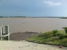
It won't affect Meredith, but there is a Lake Palo Duro north of Spearman that is going to get some water. It will be interesting to see how much it gets.
palo duro is now deeper than meredith. never in my wildest dreams would I have invisioned that reality. unreal. meredith at 44 feet and palo duro last I heard was at least 57
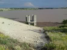
I took this on Tuesday afternoon. I was guessing the water to be 15 feet from going over the spillway. The base of this spillway used to be what, 100 - 200 yards from the edge of the lake?
Any more updates on lake?


Major flooding in Lubbock today!
my wife is in lubbock today....from what I hear it is not fun to drive around, but that town is never good in rain.
Got about 10 inches in two days in SW Lubbock. Lakeridge GC is under water.
I understand Levelland/Lubbock has exceeded their annual average already
Featured Stories
See All
Testing your trivia knowledge from A&M's SEC era
by Olin Buchanan
22:30
3d ago
5.0k
10:48
2d ago
3.9k
Outfielder Alec Blair 'blessed' to finally be an Aggie
by Richard Zane
12:44
3d ago
2.5k
Stephen McGee plays buy, sell & lease with Fourth of July plans
by Richard Zane