
BigCityCold said:
Great. Point me to the correct channel that has all this evidence and exposed data. I am willing to do the homework and have a very broad comfort zone, but haven't had any faith in Grusch, Elizondo and others since the "Age of Disclosure" grift.
You asked the question and I answered. I will put it more succinctly here: Grusch, Elizondo and Luna hold no weight with me and it has to be some other official to move the needle.
*** UAP THREAD ***
830,385 Views |
7375 Replies |
Last: 29 min ago by Redstone
Who do you need to hear it from? Serious question; the list of former and current government officials who are saying the same thing is a lot longer than Elizondo, Grusch, and Luna. If quantity doesn't carry any weight, then who are you waiting for to chime in?
Sure, it's puzzling. We should be cynical here. I keep coming back to "consilience" because we have different people across time and environment conveying rather similar concepts. Subjectively pointing to larger objective realities.
I am a believer so I don't need to be convinced. For the public in general, I believe it has to be someone in the current administration above the congressional level, and certainly not the ones that I have mentioned or Burchett.
Hard evidence is what is needed to move the needle any further than it already is. If you have the stuff, show us. There's nothing weird or puzzling or controversial about saying we need to actually see some sort of hard evidence before we fully believe that there are non-human beings flying crafts all around us at all times, that somehow only ever manage to get caught on blurry video.
What's really odd about this is that some of the people arguing the most with the doubters would also put their level of confidence somewhere less than 100%, so if you're allowed to be less than 100% sure, why am I not allowed to also be less than 100% sure?
Anyone feel free to answer, are you saying you are 100% sure that physical non-human intelligent beings are here, and flying/crashing their crafts on earth? 100%?
So, cabinet and above? Does Rubio not count? Just trying to figure out if you have someone specific in mind.BigCityCold said:
I am a believer so I don't need to be convinced. For the public in general, I believe it has to be someone in the current administration above the congressional level, and certainly not the ones that I have mentioned or Burchett.
You and I are on the same page, watty. I'm not disagreeing with you on major points like this.watty said:
Hard evidence is what is needed to move the needle any further than it already is. If you have the stuff, show us. There's nothing weird or puzzling or controversial about saying we need to actually see some sort of hard evidence before we fully believe that there are non-human beings flying crafts all around us at all times, that somehow only ever manage to get caught on blurry video.
What's really odd about this is that some of the people arguing the most with the doubters would also put their level of confidence somewhere less than 100%, so if you're allowed to be less than 100% sure, why am I not allowed to also be less than 100% sure?
Anyone feel free to answer, are you saying you are 100% sure that physical non-human intelligent beings are here, and flying/crashing their crafts on earth? 100%?
In my haste I actually misread your post, haha. Thought you said something slightly different than you had said. My bad.
"So we have people with very high jobs in the U.S. government that are either (a) liars; (b) crazy; or (c) telling the truth, and two of those three options are not good. I don't know the answer" This is a direct quote from Rubio. Does it move the needle?
To answer your question, yes Rubio, Vance or Trump himself would do so much more for disclosure than the ones that I have mentioned. I would even take the Halliburton CEO showing the latest piece of military hardware reverse engineered from alien tech as disclosure .
To answer your question, yes Rubio, Vance or Trump himself would do so much more for disclosure than the ones that I have mentioned. I would even take the Halliburton CEO showing the latest piece of military hardware reverse engineered from alien tech as disclosure .
I appreciate the response and the time that went into it.

maybe I missed it, but the Rubio cut I saw wasn't all that compelling. He just said there is stuff in the sky that we can't explain.
Quote:
Hard evidence is what is needed to move the needle any further than it already is.


To each their own I suppose. I have been researching this topic for many years now and have even touched myself into some of the 'woo' side of this. I do genuinely believe that there are pieces of this pertaining to the coverup and possibly even into the origin of humans that are kept UBER secret. That's kind of where my head is at.
Here's a thought game - what if all of this boils down to consciousness and what lies just outside our senses? That would be a complete mind screw if that was known to the public and ties UAP/dimensions/NHI/Woo all together. It seems more and more be pushing that way.
Here's a thought game - what if all of this boils down to consciousness and what lies just outside our senses? That would be a complete mind screw if that was known to the public and ties UAP/dimensions/NHI/Woo all together. It seems more and more be pushing that way.
watty said:
Hard evidence is what is needed to move the needle any further than it already is. If you have the stuff, show us. There's nothing weird or puzzling or controversial about saying we need to actually see some sort of hard evidence before we fully believe that there are non-human beings flying crafts all around us at all times, that somehow only ever manage to get caught on blurry video.
What's really odd about this is that some of the people arguing the most with the doubters would also put their level of confidence somewhere less than 100%, so if you're allowed to be less than 100% sure, why am I not allowed to also be less than 100% sure?
Anyone feel free to answer, are you saying you are 100% sure that physical non-human intelligent beings are here, and flying/crashing their crafts on earth? 100%?
100% yes. Circumstantial evidence is overwhelming if you have been looking. Now where they came from, that's a dicey topic and I'm nowhere near 100% there.
Agristotle said:
maybe I missed it, but the Rubio cut I saw wasn't all that compelling. He just said there is stuff in the sky that we can't explain.
How is this not compelling? We either have a MASSIVE intelligence failure that our enemies have cracked physics defying craft and are flying them with impunity in our skies, or it is something else entirely that we have no clue where they come from or who is operating them.
God loves you so much He'll meet you where you are. He also loves you too much to allow to stay where you are.
We sing Hallelujah! The Lamb has overcome!
We sing Hallelujah! The Lamb has overcome!
this quote has always been ridiculous. extraordinary evidence is nonsense. it requires evidence that is it. there is no such thing as extraordinary evidence
ETA: It has always been trotted out to shut down conversation. It is disingenuous at best.
ETA: It has always been trotted out to shut down conversation. It is disingenuous at best.
God loves you so much He'll meet you where you are. He also loves you too much to allow to stay where you are.
We sing Hallelujah! The Lamb has overcome!
We sing Hallelujah! The Lamb has overcome!
I found it interesting that it mirrored what watty was saying. Not trying to shut down anything.
I also disagree with your premise. Extraordinary is just an adjective, and any one particular piece of evidence from any of the various categories of evidence could be extraordinary. If the Pope came out and said an emissary of Nordic Aliens came by for a private meeting, that would be extraordinary evidence because of the source. If a spaceship landed in my backyard, that would be extraordinary evidence for me but maybe not for you.
Anyway, in my mind, it's a subjective statement about what any given observer needs in order to be convicted, not a comment about a scientific standard or anything.
I'm going to go back to a post I made a while back about Burchett and Trump. Trump said once that when they released some of this stuff "it would be interesting to some people." Then, later, Burchett said that Trump was still a skeptic. The President, one would think, would be privy to most, if not all, of the evidence. This raises 2 questions, for me. Is there not enough real evidence to convince the President? Or is there still evidence being withheld from even him?
I wonder when DOGE was cracking around if they were able to find any of the funds going to the secret programs that Grusch claimed way back when he hit the public scene. Were they shut down too fast?
I wonder when DOGE was cracking around if they were able to find any of the funds going to the secret programs that Grusch claimed way back when he hit the public scene. Were they shut down too fast?
In regard to what evidence would be "needle moving:"
1st hand testimony of crash retrieval. Lue's public stance of "yes, these programs exist, but I can't talk about them in detail publicly" is not needle moving.
Official documentation of the mission, procedures, locations of these programs, etc.
Technical documents of recovered craft or bodies
Physical artifacts of craft or bodies
To my knowledge, none of those things has been provided.
multiple claims (including Corbell, I think) of craft larger than a football field that they had to construct a building over it. Many people must know about this location.
How can THAT not be leaked to the public?
How can THAT not be leaked to the public?
This is one of the alleged sites (Anyang, South Korea.) You can see it on Google Earth.Agristotle said:
multiple claims (including Corbell, I think) of craft larger than a football field that they had to construct a building over it. Many people must know about this location.
How can THAT not be leaked to the public?


Ross Douthat on X:
Examples of religious perspectives that allow for machine consciousness:
1) pantheism/panpsychism: consciousness as a universal substrate that individuates in sufficiently- complex systems
2) powers/principalities: a world of spirits that can be summoned and speak through tech
Examples of religious perspectives that allow for machine consciousness:
1) pantheism/panpsychism: consciousness as a universal substrate that individuates in sufficiently- complex systems
2) powers/principalities: a world of spirits that can be summoned and speak through tech
Here's why I post that:
The central question of this thread is spiritual, meta-physical, consciousness. Even as The Phenomenon, to borrow the phrase of documentarian James Fox, is ALSO very much material. Please again go to Tim Alberino YouTube and watch his interview with the brothers, abductees, for a believable to me account of how the two intertwine.
But what is inescapable here is the nature of our consciousness.
Assume that demons (or, more accurately, the demon-ic) can use an ouija board as a conduit. Many millions of people, with first-hand knowledge, believe this. If so, can entities, in and out of our materialist understanding, use other means?
These are the questions Grusch has been getting at.
These are the questions Grusch has been getting at.
Douthat just released an interview with Luna that explores her disclosure efforts, in addition to other political topics. He's a very skilled interviewer.Redstone said:
Ross Douthat on X:
Examples of religious perspectives that allow for machine consciousness:
1) pantheism/panpsychism: consciousness as a universal substrate that individuates in sufficiently- complex systems
2) powers/principalities: a world of spirits that can be summoned and speak through tech
Why would you just not just dirt and plat grass? The logic doesn't follow for me
Thanks. Very interesting
AgBQ-00 said:Agristotle said:
maybe I missed it, but the Rubio cut I saw wasn't all that compelling. He just said there is stuff in the sky that we can't explain.
How is this not compelling? We either have a MASSIVE intelligence failure that our enemies have cracked physics defying craft and are flying them with impunity in our skies, or it is something else entirely that we have no clue where they come from or who is operating them.
Something you can't explain just means you that you can't explain it. Not that it's aliens.
There's a time in human history where we had no idea what stars were. People would look up at the stars and call them Gods. Now we know they are just big balls of gas billions of lightyears away.
Something that has really stuck with me was "God of the Gaps". In human history, we have attributed that which we can't understand to God. I think Aliens have recently tended to fill that gap for anything in the sky we can't understand.
except that is not what I said is it?
God loves you so much He'll meet you where you are. He also loves you too much to allow to stay where you are.
We sing Hallelujah! The Lamb has overcome!
We sing Hallelujah! The Lamb has overcome!
Well, what's your goal? Do you just want to bury it? Sure, heap some dirt and St. Augustine on top and call it done. Or do you want to study it in a controlled, stable environment?Texaguser17 said:
Why would you just not just dirt and plat grass? The logic doesn't follow for me
It wasn't really a shot at you - I apologize if you took it that way as it is not what I intended.
You said that seeing stuff in the sky that we can't explain was "compelling" evidence of either our enemies cracking physics, or something from somewhere else that we don't know who is operating it.
My point was that it very much could just be something we don't understand. For 100% of human history, we have been very wrong about understanding our universe and we just continually learn where we are wrong. Let's not pretend that today we finally have true understanding of everything.
There doesn't seem to be much information about what that facility is in Korea. According to ChatGPT, "independent researchers" have translated various map labels to "Anyang Aviation Radio Beacon." The "best" conventional explanation is it is an aircraft navigation aid, developed in the 50s. Wikipedia has an article about this tech
https://en.wikipedia.org/wiki/VHF_omnidirectional_range
I'm not going to bother with all the technical stuff, but it usually deals with circular formation and an antennae. The thing in Korea, being on the side of a cliff, may just be built with a stone wall as support.
This is about the only ground level photo I can find, assuming it's the actual location. Can't really see the antennae. Apologies if any of these pictures are really large

Here is one in Oregon,

and one in Germany

Here is a similar structure in California, though it looks much newer
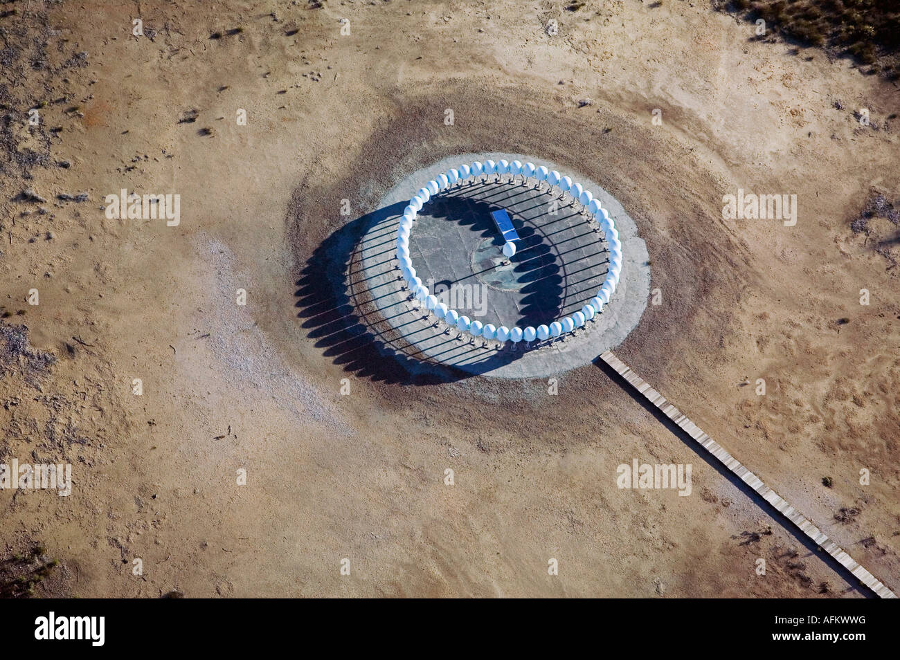
https://en.wikipedia.org/wiki/VHF_omnidirectional_range
I'm not going to bother with all the technical stuff, but it usually deals with circular formation and an antennae. The thing in Korea, being on the side of a cliff, may just be built with a stone wall as support.
This is about the only ground level photo I can find, assuming it's the actual location. Can't really see the antennae. Apologies if any of these pictures are really large
Here is one in Oregon,
and one in Germany
Here is a similar structure in California, though it looks much newer
The building in Anyang has the same kind of central antenna and ring of smaller antennas on top that the other buildings have. It could certainly be exactly what it looks like: an aviation beacon. That's probably just what it is. An aviation beacon on top of a building the size of a football field.
Yeah, for the purposes of this thread, the question is there actually something inside the large stone circle under the beacon. As I'm looking around, it appears newer built ones are all steel grid, or "mesh" design. One at the Manchester Airport in the UK is not far from a circular "ruined" structure that looks like it could be stone remnants of one of the older versions, but a lot smaller. Hard to tell from Google Earth.

Needless to say, I'm down this rabbit hole
Needless to say, I'm down this rabbit hole
That's a fair point
Featured Stories
See All
Aggie 'backers trending toward past production
by Olin Buchanan
5:45
20m ago
190
Julio Humphrey is keeping it 'strictly business' this summer
by Kay Naegeli
21:05
4h ago
2.0k
Alyssa Lang sees Texas A&M as 'stock up' under Elko
by TexAgs Live
Around the SEC: Recruiting News & Trends
by Jason Howell
16:01
1d ago
2.6k
Pass the Sticks: Angelo McCullom vs. Marco Jones
by Andrew Wu