
There is now water in front of my parents lake house on lake CC that hadn't been there in a few years.
Corpus water problems getting a reprieve
23,883 Views |
222 Replies |
Last: 6 days ago by Ag87H2O
Captain Pablo said:
Just checked the radar and that low is parked on top of Kingsville, and is drawing decent rains upstream of LCorpus. Maybe this will help
It'll help...but we need Carrizo Springs, Rocksprings, Crystal City, and Freer to be getting dumped on.
This low is 50 miles too far east.
Broseph said:
I think they are still relying on Lake Texana which is not in such a dry region as Lake CC and Choke. But if they want growth in CC, they'll need more water sources. Of course, CC has never set it sights on growth so I don't they care.
Yes. They rely not just on the Mary Rhodes pipeline to Texana, but Amari a second line to the Colorado River in Garwood. Texana gets decent rain but it's a relatively small watershed
Broseph said:
There is now water in front of my parents lake house on lake CC that hadn't been there in a few years.
That's good !

Kenneth_2003 said:
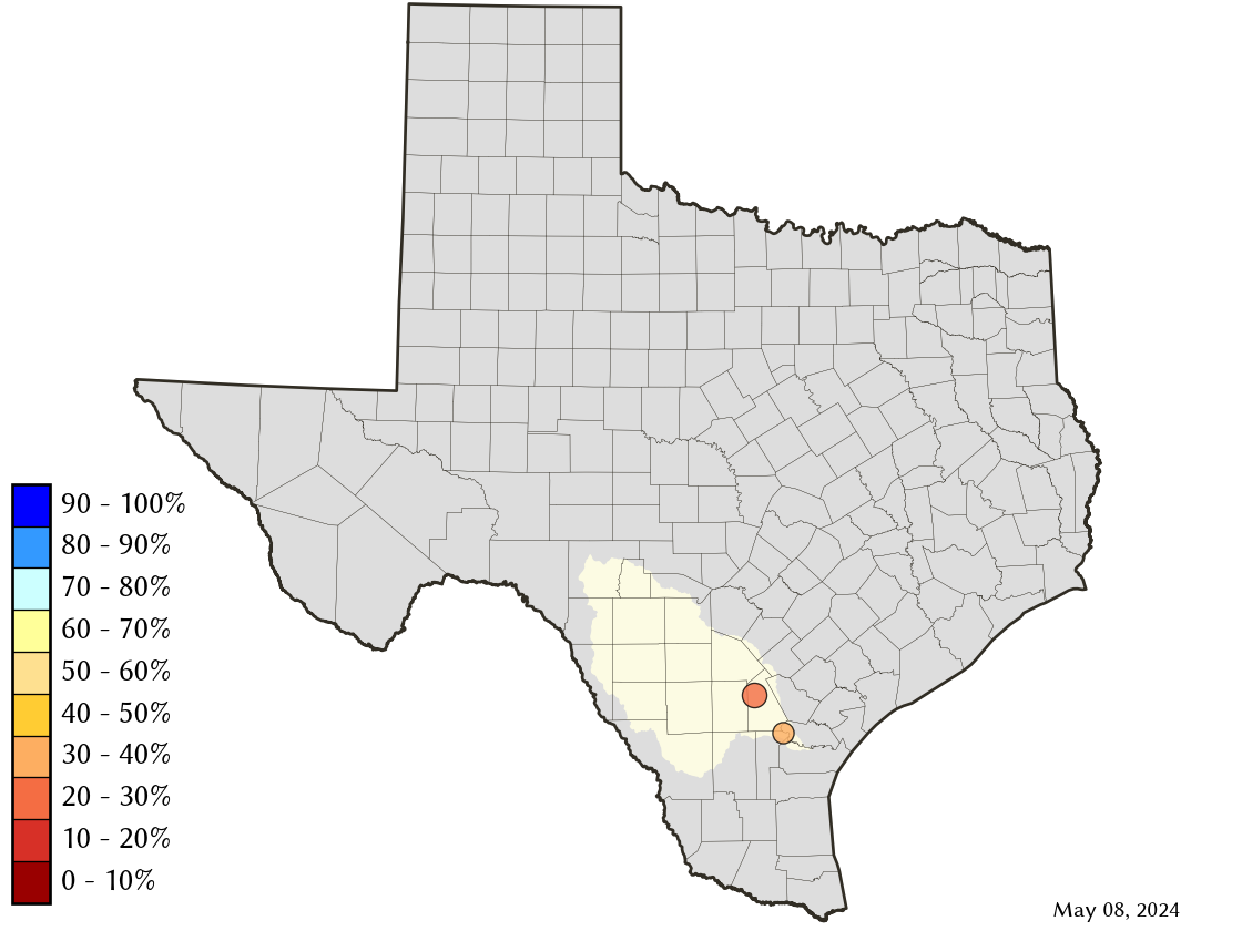
This has Mathis at 20-30%, which is accurate but it's at 29% percent right now and will be over 30% later this week. This lake was under 10% just a few weeks ago.
The Medina river feeds into the San Antonio River doesn't it? No impact on the Nueces.
K2-HMFIC said:Captain Pablo said:
Just checked the radar and that low is parked on top of Kingsville, and is drawing decent rains upstream of LCorpus. Maybe this will help
It'll help...but we need Carrizo Springs, Rocksprings, Crystal City, and Freer to be getting dumped on.
This low is 50 miles too far east.
Welp, it's happening right now
Widespread heavy rain moving into Freer from the SW now and headed NE
Active flood warnings in the Nueces watershed
We'll see if this moves the needle a little

Did last night's rain help any?
I hope I did not offend anybody with this post. If I did, please come see me at my address in my profile so we can talk.
Had really good rain between Hondo and Uvalde..around 4" in parts. Should help CC a little.
5-6" almost right on top of Medina Lake. Still waiting to see impact to that. I've learned it takes sometimes 2-3 days to see the full impact.
5-6" almost right on top of Medina Lake. Still waiting to see impact to that. I've learned it takes sometimes 2-3 days to see the full impact.
Maybe that will reach ChokeFdsa said:
Had really good rain between Hondo and Uvalde..around 4" in parts. Should help CC a little.
5-6" almost right on top of Medina Lake. Still waiting to see impact to that. I've learned it takes sometimes 2-3 days to see the full impact.
Being in TexAgs jail changes a man……..no, not really
Fdsa said:
Had really good rain between Hondo and Uvalde..around 4" in parts. Should help CC a little.
5-6" almost right on top of Medina Lake. Still waiting to see impact to that. I've learned it takes sometimes 2-3 days to see the full impact.
My Dad lives right next to the county park and said he got 5" of rain, 10" of lightning, and 10' of thunder (that's an actual quote).
ETA: It's up to 6.9% full now. It was 3.9% full a couple weeks ago.
You can turn off signatures, btw
Fdsa said:
Had really good rain between Hondo and Uvalde..around 4" in parts. Should help CC a little.
5-6" almost right on top of Medina Lake. Still waiting to see impact to that. I've learned it takes sometimes 2-3 days to see the full impact.
yeah, I saw that giant red blob parked over Medina Lake last night.
I hope I did not offend anybody with this post. If I did, please come see me at my address in my profile so we can talk.
https://dashboard.waterdata.usgs.gov/app/nwd/en/
Haven't pulled the charts for the gages around Medina... Those gages on the Nueces are days flow between each other. Interestingly tough, look at the flows on Seco creek. Up quite nicely, but the key will be to see if the gages south of 90 show any of that flow tomorrow. The ground at the base of the Hill Country is capable of drinking up vast amounts of surface flow and sending it to the aquifers. That's not a bad thing, but that must be satisfied before the surface will flow.
Haven't pulled the charts for the gages around Medina... Those gages on the Nueces are days flow between each other. Interestingly tough, look at the flows on Seco creek. Up quite nicely, but the key will be to see if the gages south of 90 show any of that flow tomorrow. The ground at the base of the Hill Country is capable of drinking up vast amounts of surface flow and sending it to the aquifers. That's not a bad thing, but that must be satisfied before the surface will flow.

75% of water is coming from lake texana. Let's hope that first storm fills that up a well. Lake CC/choke at 29.5%.
Kenneth_2003 said:
https://dashboard.waterdata.usgs.gov/app/nwd/en/
Haven't pulled the charts for the gages around Medina... Those gages on the Nueces are days flow between each other. Interestingly tough, look at the flows on Seco creek. Up quite nicely, but the key will be to see if the gages south of 90 show any of that flow tomorrow. The ground at the base of the Hill Country is capable of drinking up vast amounts of surface flow and sending it to the aquifers. That's not a bad thing, but that must be satisfied before the surface will flow.
Interesting website! Thanks!!!
Looks like the gauge at Bandera for Medina Lake is at 66 ft^3/s which is normal, but at Pipe Creek (I assume English crossing) it's 569 ft^/s...so that's A LOT going through there. I wonder if it's over the new bridge...
You can turn off signatures, btw
SMM48 said:
75% of water is coming from lake texana. Let's hope that first storm fills that up a well. Lake CC/choke at 29.5%.
Lake Texana is full. Has been for a few days.
Not certain, but in town usage might be pipeline constrained from Texana.
Ag with kids said:Kenneth_2003 said:
https://dashboard.waterdata.usgs.gov/app/nwd/en/
Haven't pulled the charts for the gages around Medina... Those gages on the Nueces are days flow between each other. Interestingly tough, look at the flows on Seco creek. Up quite nicely, but the key will be to see if the gages south of 90 show any of that flow tomorrow. The ground at the base of the Hill Country is capable of drinking up vast amounts of surface flow and sending it to the aquifers. That's not a bad thing, but that must be satisfied before the surface will flow.
Interesting website! Thanks!!!
Looks like the gauge at Bandera for Medina Lake is at 66 ft^3/s which is normal, but at Pipe Creek (I assume English crossing) it's 569 ft^/s...so that's A LOT going through there. I wonder if it's over the new bridge...
Should have bult Applewhite
Kenneth_2003 said:Ag with kids said:Kenneth_2003 said:
https://dashboard.waterdata.usgs.gov/app/nwd/en/
Haven't pulled the charts for the gages around Medina... Those gages on the Nueces are days flow between each other. Interestingly tough, look at the flows on Seco creek. Up quite nicely, but the key will be to see if the gages south of 90 show any of that flow tomorrow. The ground at the base of the Hill Country is capable of drinking up vast amounts of surface flow and sending it to the aquifers. That's not a bad thing, but that must be satisfied before the surface will flow.
Interesting website! Thanks!!!
Looks like the gauge at Bandera for Medina Lake is at 66 ft^3/s which is normal, but at Pipe Creek (I assume English crossing) it's 569 ft^/s...so that's A LOT going through there. I wonder if it's over the new bridge...
Should have bult Applewhite
I was a Chris Simms hater too...
You can turn off signatures, btw
Well we honestly should and do hate all of them...
But San Antonio folks should recall the Applewhite dam project that was killed by voters in 1991. Site engineering and archeology was progressing, this would have created another reservoir downstream of Medina before the water dumps into the San Antonio River.
I know this is a Corpus thread, but folks keep bringing up Lake Medina. The Medina river meets up with the San Antonio and heads toward Floresville, Karnes City, & Goliad
Kenneth_2003 said:
Well we honestly should and do hate all of them...
But San Antonio folks should recall the Applewhite dam project that was killed by voters in 1991. Site engineering and archeology was progressing, this would have created another reservoir downstream of Medina before the water dumps into the San Antonio River.
I know this is a Corpus thread, but folks keep bringing up Lake Medina. The Medina river meets up with the San Antonio and heads toward Floresville, Karnes City, & Goliad
Meh.
I graduated HS in SA in 1986. My folks moved from their SA house to their Medina Lake (say it right) house right after I left.
I was working up in DFW by 1991.
But, most people don't realize that Medina Lake was create as an irrigation lake for the communities around the area. It was never supposed to be a "reservoir".
That's part of the reason it goes up and down so much.
You can turn off signatures, btw
Sorry. I made a mistake. Total system is 12%. Lake Corpus Christi is at 29%
Kenneth_2003 said:SMM48 said:
75% of water is coming from lake texana. Let's hope that first storm fills that up a well. Lake CC/choke at 29.5%.
Lake Texana is full. Has been for a few days.
Not certain, but in town usage might be pipeline constrained from Texana.
I believe CC uses 100 million a day and 60-70 mill comes from Mary Rhodes pipeline. Something like that.
That's true, but the biggest reason fluctuates so much is because the drainage area from the Medina River upstream of the lake is too small.
Wall of water still coming down the Nueces
Tilden expected to crest at Moderate flood stage
Three R. Up as well
Should make an impact
Tilden expected to crest at Moderate flood stage
Three R. Up as well
Should make an impact
1300 cfs for 24 hours is 2600 acre feet. It's not nothing but that flow work need to be sustained for about 2.5 months to fill Lake CC
Kenneth_2003 said:
1300 cfs for 24 hours is 2600 acre feet. It's not nothing but that flow work need to be sustained for about 2.5 months to fill Lake CC
I don't think anybody thought it would fill the lake.
But raise it a few percentage points? Yes, that's probably gonna happen, and will be very helpful, especially if we hit drought conditions this summer.
All this being said, with lake Mathis approaching one third capacity, and Texana having water to spare, how much are we gonna hear about desalinization plants in the next six months?
My guess is, not much.. lol
Absolutely, every drop helps and especially so in regards to the Lake for places like Beeville who's raw water intake is in Mathis. These recent rains have put much needed water depth over their intake. They too are finally drilling brackish wells for reverse osmosis; a position that was voted down (don't get me started) in the early/mid 20-teens.
I agree with you, I won't underestimate Corpus' ability to kick the can down the road and do the wrong thing.
I agree with you, I won't underestimate Corpus' ability to kick the can down the road and do the wrong thing.
Captain Pablo said:Kenneth_2003 said:
1300 cfs for 24 hours is 2600 acre feet. It's not nothing but that flow work need to be sustained for about 2.5 months to fill Lake CC
I don't think anybody thought it would fill the lake.
But raise it a few percentage points? Yes, that's probably gonna happen, and will be very helpful, especially if we hit drought conditions this summer.
All this being said, with lake Mathis approaching one third capacity, and Texana having water to spare, how much are we gonna hear about desalinization plants in the next six months?
My guess is, not much.. lol
Exactly…corpus "leadership" (used very loosely here) will declare crisis resolved and scrap all desal plans.
Ans corpus will be in the same situation in 8 months with no progress in a future resolution
The Evangeline groundwater project is under construction right now. "No progress" is already incorrect to the tune of 25-28 MGD once that is online. The only potential roadblock is the permit protest, but I suspect that will get worked out. The city attorneys seem to think so.
We'll see on desal, but I think the momentum is still there. I don't think there is anyone in the entire region that thinks that the problem is solved because it is raining right now except critics who want to take cheap shots. Everyone knows this problem will return.
We'll see on desal, but I think the momentum is still there. I don't think there is anyone in the entire region that thinks that the problem is solved because it is raining right now except critics who want to take cheap shots. Everyone knows this problem will return.
Kenneth_2003 said:
Absolutely, every drop helps and especially so in regards to the Lake for places like Beeville who's raw water intake is in Mathis. These recent rains have put much needed water depth over their intake. They too are finally drilling brackish wells for reverse osmosis; a position that was voted down (don't get me started) in the early/mid 20-teens.
I agree with you, I won't underestimate Corpus' ability to kick the can down the road and do the wrong thing.
Is the Nueces super narrow at Tilden?
It's at Moderate flood stage, and is up 14 feet
But only flowing at 1400 cfs
Seems odd
American Hardwood said:
The Evangeline groundwater project is under construction right now. "No progress" is already incorrect to the tune of 25-28 MGD once that is online. The only potential roadblock is the permit protest, but I suspect that will get worked out. The city attorneys seem to think so.
We'll see on desal, but I think the momentum is still there. I don't think there is anyone in the entire region that thinks that the problem is solved because it is raining right now except critics who want to take cheap shots. Everyone knows this problem will return.
I hate to see more reliance on groundwater. Those aquifers are gonna dry up at some point. Possibly soon
There will be a day of reckoning for sure, and West Texas (Panhandle/South Plains) will probably be the first to get whacked
Captain Pablo said:Kenneth_2003 said:
Absolutely, every drop helps and especially so in regards to the Lake for places like Beeville who's raw water intake is in Mathis. These recent rains have put much needed water depth over their intake. They too are finally drilling brackish wells for reverse osmosis; a position that was voted down (don't get me started) in the early/mid 20-teens.
I agree with you, I won't underestimate Corpus' ability to kick the can down the road and do the wrong thing.
Is the Nueces super narrow at Tilden?
It's at Moderate flood stage, and is up 14 feet
But only flowing at 1400 cfs
Seems odd
I think it's a velocity issue not so much a channel size thing. Been a while since I've run around those roads but points up stream the Nueces is almost devoid completely of any real channel though by Tilden I think it is more channelized.
I'm thinking specifically when I used to cross it on 624 vs that gage on 16
I don't see it as THE answer long term, but it can be a stop gap measure now, and a component of a future comprehensive water management system in combination with existing surface water sources and future desal.
The hydrology reports as I understand them, say the Evangeline aquifer would supply the water demand of the water project for a VERY long time. However there is no guarantee that others won't tap it too.
The city of Sinton, in a bold move of hypocrisy considering they are protesting Evangeline permits, have submitted for well permits too for example.
American Hardwood said:
I don't see it as THE answer long term, but it can be a stop gap measure now, and a component of a future comprehensive water management system in combination with existing surface water sources and future desal.
The hydrology reports as I understand them, say the Evangeline aquifer would supply the water demand of the water project for a VERY long time. However there is no guarantee that others won't tap it too.
The city of Sinton, in a bold move of hypocrisy considering they are protesting Evangeline permits, have submitted for well permits too for example.
Dang! You seem a little biased. lol
How much would Sinton use as compared to Corpus (including industry)
I am biased against Sinton in this. Almost all of the rest of San Pat county relies on CC water and Sinton is trying to kill the project based on political grandstanding and fear mongering. The exact thing so many on this thread alone are criticizing CC for. You want to know why the water situation wasn't dealt with years ago? It's that right there.
Featured Stories
See All
37:21
8h ago
3.8k
Leroy Burrell hired as 20th head coach of Texas A&M track & field
by Olin Buchanan
2027 IMG Academy WR Eric McFarland III commits to A&M
by Jason Howell
14:33
9h ago
1.9k
6:32
1d ago
6.0k
In-Home Visit: A&M adds five-star WR in uber-athletic Eric McFarland III
by TexAgs Recruiting
MTVs Celebrity Deathmatch
Any Kyle Field improvements to be aware of?
in Billy Liucci's TexAgs Premium
42